
Many Estonians are frantically looking for a way to get some fresh air in the wild. As a result, scenic places and hiking trails near big cities are often overcrowded. There is no such concern in Tõrva parish because we have an abundance of places with natural beauty, and even if some of them happen to be crowded, you can easily find a more private hiking spot.
Tõrva hiking trail
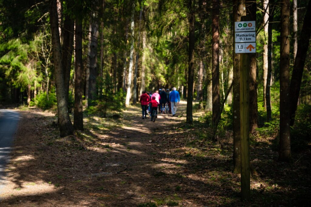
Tõrva health trail is 11.1 km long and it runs among beautiful places with diverse nature. The hiking trail starts from the park of Tõrva Gymnasium and there are several sights along the trail: Keisripalu forest, Orjakivi sacrificial stone, Helme cemetery, Tikste ancient valley with Tikste and Pokardi reservoirs and Tikste creek, on the shore of which you can see a sandstone outcrop and a spring believed to have medicinal powers. The trail also passes through an arboretum, Tantsumäe and Linnamäe hills, next to the trail are the lakes Riiska and Vanamõisa and the river Õhne. Various activities promoting movement and health sports take place on the Tõrva health trail all year round: Tantsumäe hill run, cross-country bike winter and summer cross, Tõrva triathlon, Tõrva three lake run.
Taagepera-Ala hiking trail
Taagepera hiking trail with a total length of 5.4 km starts and ends at the Taagepera campfire site where camping is also allowed. The trail partly runs along the banks of the river Õhne and is also passable in smaller circles (1.6 km and 4.0 km in length). The trail has wooden signposts and an information board. The main attractions along the hiking trail are the castle and the castle park, Taagepera church and cemetery, the family burial plot of the barons, ‘Musukivi’ rock, a sacrificial stone, an underground cemetery and the river Õhne. A truly inspiring hike intertwined with history, architecture and primeval nature.
Lake Koorküla Valgjärv
Lake Koorküla Valgjärv and the campfire sites are located in the Sakala recreation area. The lakeshore, with the most beautiful sandy beaches in this area, is an ideal place for family holiday. The first campfire site is large enough for several groups of people and the sandy beach also provides an opportunity for swimming. The second campfire site is suitable for a modest lonely wanderer. Camping is allowed at both campfire sites. According to the local lore you have to be careful when swimming there because the location of the onetime manor is on the bottom of the lake and water-dwellers live there.
Lake Tündre campfire site and nature reserve
Lake Tündre campfire site and nature reserve are also located in the Sakala recreation area. It is possible to spend a longer holiday on the shores of the beautiful lake Tündre. The solid shelter protects against poor weather and the place also has a dry toilet, an information board, a campfire site with a roof and a barbeque grill, a woodshed and a swimming site. There are a lot of fish in the lake and it is a perfect place for a warm swim in the summer. To launch a boat, go to the adjacent Tündre campfire site. The forests around the lake are full of berries and mushrooms.
Pikasilla recreation area
Pikasilla recreation areaat the southern tip of lake Võrtsjärv is easily accessible and strategically well located by the waterway (at the mouth of the river Väike Emajõgi). The place is known as a venue for various sporting and public events. The area has various sports facilities, boat harbour with rental, children’s playground, camping area, campsites and a campfire site. Washing and cooking facilities are also available. The place is highly valued by both local and distant fishermen.
Rubina swamp and bog
Rubina bog is located in the southwest corner of lake Võrtsjärv and is also known as Lagesoo and Tõrusoo. It is one of the largest, most valuable and best-preserved bogs in the region. Rubina bog is an old and well-developed swamp created over several millennia with its characteristic hollows, numerous bog pools and bog lakes. Based on the map and aerial photography, more than 400 bog pools with a total area of approximately 18 ha have been distinguished. There are also larger bog lakes which can stretch up to a few hundred meters long. Many birds have chosen Valga county’s Rubina bog as their nesting place. Lake Veisjärv which is situated in Viljandi county, with its boggy shores, is an important feeding area for the birds. The pine forest on the sand dunes is a suitable habitat for the Western capercaillie, lesser spotted-eagle and other rare birds. Bears, elk, wolves and lynx tread the grounds of the nature reserve and deer live nearby. You can also take part in bog shoe hikes organized by Imre Arro (more information at loodusturism.ee). The bog shoe hike takes place in a waterbody-rich swamp and during the hike traces of animal activities are introduced, searched and explained (excrements, feeding traces, markings of the territory, bone remains etc.). Knowledgeable guides talk about the behavioural habits of animals and birds and other adventures in nature.
Vooremäe recreation area
Vooremäe recreation area on the southern shore of lake Võrtsjärv is known for its hill fort from the beginning of the second millennium, to which several legends are also associated. It is a peaceful and relatively remote place, which is enjoyed precisely because of the natural beauty of the place and the great view from the top of the hill fort. The place is also known as an excellent bird watching area. In 2010, the roadway was reconstructed in cooperation with the Võrtsjärv Foundation and Puka parish and also a proper boat dock was built.
Soontaga hiking trail
The trail runs along a typical southern Estonian mixed forest terrain, reaching the river Väike Emajõgi. There are several information stands along the hiking trail that describe the nature of the area. The 2.9 km long trail has signposts and two bridges.
Helme caves
Probably the most magnificent grottoes in Estonia can be seen in Helme manor park. White sandstone is exposed by about three meters in the caves, north of the castle ruins. The cave system once consisted of seven halls connected by passages, the largest of which was called the Church of Moses, however, by now some of the caves have collapsed. By the way, the caves were originally carved by springs but people have expanded them later and used as a refuge. Helme caves have also been called Hell among the ancient people. It is always a pleasure to take a small hiking trip around the caves, castle ruins and Helme manor territories.
Teringi study trail
Teringi study trail lies only 30 kilometres from Tõrva in Mulgi parish. The 4.5 km loop trail is ideal for people who are not wearing special hiking clothes. The boardwalk and a safe woodchip path take the visitor across several bog islands and the information boards along the trail give an ample overview of wild animals and ecological bog communities. A refreshing dip can be done in the brown-water lake Alatsi.
The article was published in Tõrva Teataja in 2020
Egon Ilisson